Aircraftcompare
Aircraftcompare High-Performance Engineering Platform
Aeronautical Telemetry Desk • ICAO Annex 3

Aviation METAR Decoder & Weather Telemetry

Decode raw airport surface weather observations, verify certified runway visual ranges, and determine flight dispatch categories across global aerodromes.

FAA Part 25 & EASA CS-25 Certified Specifications Verified OEM Planning Data: Boeing APD & Airbus FCOM ICAO Doc 9157 Aerodrome Standards
AI-Assisted Telemetry & 16:9 Visuals · Methodology & Policy

Live Aerodrome Observation Station

Enter any 4-letter ICAO identifier or select a commercial hub preset below.

Connecting to NOAA Aviation Weather Feed...
Major Hub Presets:

Official WMO Alphanumeric Telemetry VFR
KORD 091151Z 24014G22KT 10SM BKN045 OVC090 14/06 A2992 RMK AO2 SLP131
Aerodrome Facility Chicago O'Hare International
Surface Wind Vector 240° at 14 knots, gusting 22 kt
Surface Visibility 10 Statute Miles (Unrestricted)
Temperature & Dew Point 14°C (Dewpoint: 6°C)
Altimeter (Barometric) 29.92 inHg (1013 hPa)
Cloud Ceilings & Layers Broken at 4,500 ft AGL

Aerodrome Telemetry Standards ICAO Annex 3 • WMO FM 15-XV • FAA Order 7900.5
Automated ASOS/AWOS Standards

Deciphering METAR Weather Syntax for Flight Dispatch

Visual Flight Rules (VFR)

Permits flight operations entirely by outside visual references without instrument navigation. Under Federal Aviation Regulations (FAR Part 91.155) and ICAO standards, VFR requires an aerodrome cloud ceiling of at least 3,000 feet Above Ground Level (AGL) and flight visibility of not less than 5 statute miles (8 kilometers).

Marginal VFR (MVFR)

Visual navigation remains authorized but requires heightened pilot situational awareness and pre-flight planning. Defined by cloud ceilings between 1,000 and 3,000 feet AGL and/or surface visibility between 3 and 5 statute miles. Pilots must be prepared for swift transitions to instrument conditions.

Instrument Flight Rules (IFR)

Mandatory flight operations on instruments with Air Traffic Control separation within controlled airspace. Triggered whenever the airport ceiling drops between 500 and 1,000 feet AGL or visibility diminishes between 1 and 3 statute miles. Mandatory filed IFR flight plan and certified avionics.

Low IFR (LIFR) & Category II/III Operations

Represents severe instrument meteorological conditions. Designated when ceilings drop below 500 feet AGL or visibility is less than 1 statute mile. Precision instrument approaches (CAT II or CAT III ILS) require autoland systems, heads-up displays, and certified flight crew recurrent training.


Flight Rule Thresholds VFR ≥ 3,000 ft / 5 SM • IFR < 1,000 ft / 3 SM
FAR Part 91.155 • ICAO Doc 9157

Barometric Altimeter Calibration (QNH vs inHg)

Altimeter settings calibrate sensitive aircraft barometers to local sea-level atmospheric pressure. North American stations report pressure in inches of mercury (A2992 represents 29.92 inHg), while international airports report QNH in hectopascals (Q1013 indicates 1013 hPa). Sub-freezing temperatures demand cold-temperature altitude corrections to ensure physical obstacle clearance during final approach segments.

Cloud Coverage Hierarchy & Obscurations

Cloud layers are evaluated in oktas (eighths of celestial dome): FEW represents 1-2 oktas, SCT denotes 3-4 oktas, BKN indicates 5-7 oktas, and OVC constitutes complete 8-okta coverage. By statutory definition, the lowest broken or overcast layer establishes the official aerodrome ceiling governing approach minimums.

Runway Visual Range (RVR) & Weather Descriptors

When surface visibility declines, calibrated transmissometers alongside the runway measuring zone report Runway Visual Range in hundreds of feet (e.g. R04R/2400FT). Alphanumeric weather descriptors convey precipitation type and intensity, such as light rain (-RA), heavy thunderstorm (+TSRA), mist (BR), or freezing fog (FZFG).

ICAO Annex 3 & WMO Telemetry Architecture

Global meteorological aerodrome reports conform to World Meteorological Organization standard FM 15-XV and ICAO Annex 3. Automated surface observing stations (ASOS/AWOS) continuously sample anemometer arrays, laser ceilometers, and precipitation discriminators to deliver synchronized digital flight telemetry to international flight dispatch desks worldwide.

Meteorological Telemetry RVR • Ceilometers • Altimeter Settings • LLWAS Windshear
ICAO Annex 3 • WMO FM 15-XV • FAA AC 00-45

Pre-Flight Dispatch Meteorology & Crosswind Runway Allocation

Crosswind Trigonometry & Runway Heading Alignment

Surface wind vectors must be resolved into orthogonal crosswind and headwind components relative to the active runway centerline. When winds are reported as 240° at 20 knots and Runway 28 is active (magnetic orientation 280°), the angular difference is 40 degrees. The crosswind component equals wind speed multiplied by the sine of the angle (20 × sin(40°) = 12.8 knots), while headwind component equals wind speed multiplied by the cosine of the angle (20 × cos(40°) = 15.3 knots). Operators compare calculated crosswinds against certified maximum demonstrated crosswind limits published in the Aircraft Flight Manual (AFM).


Density Altitude Computations & Turbine Performance Degradation

Density altitude represents pressure altitude corrected for non-standard atmospheric temperature. In high-temperature or high-elevation aerodromes (such as Denver KDEN or Dubai OMDB during summer operations), density altitude significantly exceeds physical field elevation. Elevated density altitude diminishes air density, degrading aerofoil lift production and reducing turbine engine mass airflow. As a consequence, takeoff roll distances lengthen substantially, climb gradients shallow, and certified maximum takeoff weights must frequently be decremented to honor second-segment obstacle clearance slopes under FAR Part 25 transport category airworthiness certifications.

Wind Shear Alerts & Microburst Detection Architecture

Terminal Aerodrome METAR remarks (RMK) frequently report Low-Level Wind Shear (LLWS) detected by Terminal Doppler Weather Radar (TDWR) and Low-Level Windshear Alert Systems (LLWAS). Rapid horizontal airspeed gains or losses exceeding 15 knots, coupled with vertical downdrafts during final approach or initial climb-out, trigger mandatory flight crew windshear escape maneuvers under FAA Advisory Circular AC 120-41. Modern commercial airline dispatch protocols mandate diversion to alternate aerodromes whenever severe microburst alerts are active over active runway threshold zones.


ICAO Annex 3 Alphanumeric Sky Coverage Classifications & Ceiling Standards
METAR / TAF Code Sky Coverage (Oktas) Aviation Ceiling Status Commercial Dispatch Impact
SKC / CLR 0 oktas (0%) No Ceiling (Clear Sky) Unrestricted visual approaches; standard visual flight rules (VFR) operating minimums apply.
FEW 1 to 2 oktas (12.5% – 25%) Not a Certified Ceiling Scattered daylight illumination; does not restrict Category I ILS precision descent procedures.
SCT 3 to 4 oktas (37.5% – 50%) Not a Certified Ceiling Partial celestial dome occlusion; pilot visual contact maintained during intermediate approach.
BKN 5 to 7 oktas (62.5% – 87.5%) Certified Aviation Ceiling Constitutes an official ceiling under ICAO Annex 3; determines destination and alternate landing minimums.
OVC 8 oktas (100%) Certified Aviation Ceiling Total sky obscuration; requires instrument flight rules (IFR) and precision instrument landing system approach.
VV Vertical Visibility Indefinite Surface Ceiling Reported in surface fog or heavy snow (e.g. VV002 = 200 ft); triggers low-visibility Category II/III autoland procedures.
Entry #1 SKC / CLR
Sky Coverage (Oktas) 0 oktas (0%)
Aviation Ceiling Status No Ceiling (Clear Sky)
Commercial Dispatch Impact Unrestricted visual approaches; standard visual flight rules (VFR) operating minimums apply.
Entry #2 FEW
Sky Coverage (Oktas) 1 to 2 oktas (12.5% – 25%)
Aviation Ceiling Status Not a Certified Ceiling
Commercial Dispatch Impact Scattered daylight illumination; does not restrict Category I ILS precision descent procedures.
Entry #3 SCT
Sky Coverage (Oktas) 3 to 4 oktas (37.5% – 50%)
Aviation Ceiling Status Not a Certified Ceiling
Commercial Dispatch Impact Partial celestial dome occlusion; pilot visual contact maintained during intermediate approach.
Entry #4 BKN
Sky Coverage (Oktas) 5 to 7 oktas (62.5% – 87.5%)
Aviation Ceiling Status Certified Aviation Ceiling
Commercial Dispatch Impact Constitutes an official ceiling under ICAO Annex 3; determines destination and alternate landing minimums.
Entry #5 OVC
Sky Coverage (Oktas) 8 oktas (100%)
Aviation Ceiling Status Certified Aviation Ceiling
Commercial Dispatch Impact Total sky obscuration; requires instrument flight rules (IFR) and precision instrument landing system approach.
Entry #6 VV
Sky Coverage (Oktas) Vertical Visibility
Aviation Ceiling Status Indefinite Surface Ceiling
Commercial Dispatch Impact Reported in surface fog or heavy snow (e.g. VV002 = 200 ft); triggers low-visibility Category II/III autoland procedures.
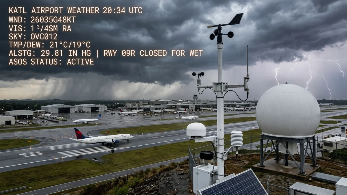
Aviation METAR weather radar and airport runway meteorological telemetry
Aviation Weather Telemetry: Live METAR airport surface observations and flight dispatch categories.
P1 Flight Operations Suite

Aeronautical Calculators & Telemetry Envelopes

Crosswind Vector 10.0 kts
Headwind / Tailwind Vector 17.3 kts Headwind
Wind Angle Offset (Δθ) 30°
Pressure Altitude (PA) 2,500 ft
Density Altitude (DA) 4,894 ft
ISA Temperature Deviation +20.0°C
High Density Altitude (4,894 ft): Severe engine thrust degradation, prolonged takeoff roll, and reduced climb gradient.
Supported format: ICAO string with wind vector (e.g. 31015G25KT).
Parsed Wind Direction 310°
Sustained Wind Speed 15 kts
Peak Gust Velocity 25 kts
What is an aviation METAR report?

A METAR (Meteorological Aerodrome Report) is an international standard format for surface weather observations at airports, typically issued every 30 to 60 minutes in accordance with ICAO Annex 3 and WMO standards.

How do I determine flight categories from a METAR?

VFR (Visual Flight Rules) requires ceiling greater than 3,000 ft AGL and visibility over 5 miles. MVFR requires ceiling 1,000 to 3,000 ft or visibility 3 to 5 miles. IFR requires ceiling 500 to 1,000 ft or visibility 1 to 3 miles. LIFR (Low IFR) occurs when ceiling is below 500 ft or visibility is under 1 mile.

How is wind reported in a METAR string?

Wind is reported as a 5-to-7 character group: the first three digits indicate true direction in tens of degrees (e.g. 240 is 240°), followed by two digits for sustained speed in knots (KT). If gusting, a 'G' is followed by the peak gust speed.


```